
Evolving Community
Comprehensive Plan: Chapter 3
If you experience any difficulty accessing this information, please contact us at 208-884-5533 or [email protected] for assistance. You may also submit a request using our ADA Grievance Form.
Overview
Since 1990, Meridian has experienced exponential growth, becoming the second largest city in Idaho and one of the top ten fastest growing cities in the nation. Due to the desirability of the area, population growth will continue. Over the last 20 years, property in and around Meridian has changed from primarily agricultural and single-family residential to include a more diverse mix of residential types and commercial and industrial uses. That trend will continue as land traditionally used for agriculture develops at urban intensities. However, the foremost goals will remain to grow the city as a premier place to live, work, and play.
The Plan embraces Meridian as an Evolving Community by focusing on strategically planning for future growth. It provides new land use tools to ensure strategic and sustainable growth through the provision of services and infrastructure consistent with this Plan’s vision. Essential to community health is the promotion of responsible land use and growth by ensuring that development pays for itself and enhances the quality and character of the community. Reinventing key areas, supporting infill, and focusing growth in strategic areas support an efficient and high-quality development pattern that aligns with the availability and capacity of services and infrastructure.
As part of the Evolving Community Vision, the following elements are included in this chapter:

Growth and Population
Introduction
The Growth and Population element reinforces the City’s commitment to meet and protect the needs of existing residents and businesses in tandem with future population growth and land development. Policies in this section address how to plan for the redevelopment of properties already within the corporate boundaries of the City and its Area of City Impact, and guide growth to priority areas, all while protecting private property rights.
Background
Understanding the implications of changing demographics and population projections enables a community to anticipate and effectively plan for future market conditions and how best to meet its residents’ future needs. COMPASS, the agency responsible for regional transportation planning, estimates that by 2040 the regional population total will exceed 1 million people. At the center of all this, very conservative estimates put Meridian’s population at over 160,000 people in the same time period. COMPASS updates these numbers yearly to reflect recent growth. As Meridian continues to grow and respond to development pressure, it is important to employ tools and planning protocols that guide responsible development and the expansion of public utilities and services.
The City of Meridian’s leaders and staff adopt and enforce policies and regulations that govern the City, in addition to applicable state and federal laws. Meridian is committed to authentic citizen engagement in government through participation on boards, commissions, and committees, as well as through public feedback as part of planning initiatives.
Area of City Impact
In accord with § 67-6526 of Idaho Code, unincorporated properties within the City’s Area of City Impact (AOCI) are governed by Ada County for day-to-day administration of zoning matters. However, there is an agreement between Ada County and Meridian for the Area of City Impact. This agreement states that the current Meridian Comprehensive Plan will apply within the City’s established AOCI.
Within the AOCI, the county has generally applied a Rural Urban Transition (RUT) zone which permits five-acre-lot, single-family residential development, as well as agricultural-related uses and a range of conditional uses. County development applications within the AOCI are reviewed by the City of Meridian for compliance with the comprehensive plan and applicable City policies.
The City of Meridian desires, over time, all development within its Area of City Impact to be served with urban services from the City of Meridian. Such services primarily include sanitary sewer, water, reclaimed water, fire, police, and parks. Secondarily, the City considers the availability and capacity of the school system, transportation facilities, libraries, and storm water facilities in any review of development within the AOCI. All requests for annexation into the City limits will require that the owner extend City-owned services at the time of development.
The importance of cooperating with Ada County and neighboring cities is imperative to successful long-term land use, transportation, and utility planning. There are very significant financial and quality-of-life implications for not doing so. As such, the City of Meridian is committed to fulfilling the terms of its Area of City Impact Agreement with Ada County and coordinating with adjacent service providers.
Meridian aims to guide growth in a way that efficiently expands infrastructure and services to support sustainable growth patterns. Targeting the right development and growing responsibly – in the right locations with the right services – is the foundation of the Evolving Community Vision.
Plans for specific areas, corridors, and infrastructure provide the next level of detail for implementation of the vision, including Urban Renewal Districts and Opportunity Zones. These following policies address utility and service expansion, transportation, quality development, fiscal impact, and compatibility with Meridian’s Unified Development Code, among other attributes the community values regarding growth and population.
Property Rights
The City of Meridian respects the rights of its citizens and their property, and is committed to counter negligence, abuse or devaluing of private property by others. Residents should feel their private property rights are respected and secure. See Appendix C for a checklist used in reviewing proposed regulations or actions to ensure compliance with private property rights.

Future Land Use
Introduction
The Future Land Use element emphasizes the importance of thoughtful and responsible land use planning, cooperation, and collaboration among the various jurisdictions and agencies in the area, and preservation and enhancements of the high quality of life that currently exists in Meridian. The policies in this section are graphically represented in the Future Land Use Map.
Background
Planning in a deliberate manner, with an understanding of market, financial, and physical realities, can help foster a healthy balance of land uses and minimize uncertainty for officials, staff, residents, and others. Land use planning is an important tool in attracting and retaining the residents, businesses, and visitors that sustain the community’s economy and contribute to a city’s high quality of life. As such, it is important to continually evaluate what changes are needed to ensure that the community grows the way it desires.
The location and balance of land uses and densities should be efficient and sustainable; enhance community identity; support a multimodal transportation network; provide housing choices near jobs, schools, shops, and parks; minimize conflicts between incompatible uses; and integrate development with existing and planned infrastructure. See the Transportation element in the Connectivity Chapter of this Plan for more information on Transportation and Land Use Integration.
Transportation, Land Use, and Corridors
The transportation network plays an especially critical role in the location, types, and balance of land uses across the City. Two types of corridors that are particularly relevant to the land use policies are defined below. (See Chapter 6) for more on transportation and land use integration.
Future Land Use Map
Mapping future land uses is a key component of the Comprehensive Plan, so that development occurs in the direction and manner most desired by the community.
The Future Land Use Map (FLUM) identifies the vision for a portfolio of land uses to implement the City’s many diverse goals and objectives, and works in conjunction with the text of the Comprehensive Plan, City Code and various policies of the City. In addition, the FLUM is closely aligned with ACHD’s Master Street Map (MSM). The MSM is the transportation equivalent of the City’s Future Land use Map and reflects a built-out collector and arterial street network. The FLUM is not a zoning map and differs in that the FLUM describes the character and type of use that is desired in the future and not necessarily what is currently in place. The FLUM depicts a built-out Meridian that is very diverse in residential densities, commercial and industrial land uses as well as civic/public opportunities.
Descriptions of the various future land use designations that appear on the FLUM are described on the following pages. The FLUM is shown in Appendix D.
Symbols
All “future” symbols shown on the Future Land Use Map, such as parks, schools, fire and police stations, transit stations, etc., represent generalized locations based on the best information the City has to date. All such symbol locations are to be considered conceptual and not exact locations. All “existing” symbols shown on the Future Land Use Map for parks, schools, fire and police stations, etc. represent precise locations based on the facilities in place at the time of Plan adoption.
General Guidance
Future Land Use designations are not parcel specific. An adjacent, abutting designation, when appropriate and approved as part of a public hearing with a land development application, may be used. A designation may not be used however, across planned or existing collector or arterial roadways, must not be used on a parcel not directly abutting the designation, and may not apply to more than 50% of the land being developed. All other changes to designations must be approved through a Comprehensive Plan Map Amendment. Sample zoning listed in the future land use designation descriptions does not preclude the use of other zoning districts provided the proposed project is consistent with the description of the land use designation.
Difference Between Future Land Use and Zoning
The Comprehensive Plan’s Future Land Use descriptions and map work in tandem with the Plan’s policies to help direct development patterns citywide to achieve the #MyMeridian Vision. They determine the desired character of new development, range of densities allowed, and intensity and mix of uses.
- The City of Meridian Unified Development Code (UDC) defines a series of zoning districts that are much more specific in terms of allowed uses and other development and operational requirements than future land use designations.
- The future land use designations help determine what type of zoning new development may receive when a project applies for annexation into the City, or what allowances exist for a property to rezone. However, the future land use designations and zoning districts are not a one-to-one with each other. Some future land use designation descriptions in this chapter include sample zoning. Sample zoning listed does not preclude the use of other zoning districts provided the proposed project is consistent with the description of the land use designation.
- Contact the Meridian Planning Division for more information on what zoning districts typically apply to the various Future Land Uses.
Residential Land Uses
The purpose of this designation is to provide for a variety of housing types and densities varying from large estate or semi-rural lots to multi-family homes. In all cases, urban services such as sewer, water, parks, and emergency services should be provided. Residential designations are described in following pages.
Within residential areas the following ideas and policies shall apply:
- The Comprehensive Plan encourages a variety of product types and lot sizes within every neighborhood.
- Gross residential densities are rounded to the nearest whole number.
- At the discretion of City Council, areas with a Residential Comprehensive Plan designation may request an office use if the property only has frontage on an arterial street or section line road and is two acres or less in size. In this instance, no ancillary commercial uses shall be permitted.
Low Density Residential
This designation allows for the development of single-family homes on large and estate lots at gross densities of three dwelling units or less per acre. These areas often transition between existing rural residential and urban properties. Developments need to respect agricultural heritage and resources, recognize view sheds and open spaces, and maintain or improve the overall atmosphere of the area. The use of open spaces, parks, trails, and other appropriate means should enhance the character of the area. Density bonuses may be considered with the provision of additional public amenities such as a park, school, or land dedicated for public services.
Medium Density Residential
This designation allows for dwelling units at gross densities of three to eight dwelling units per acre. Density bonuses may be considered with the provision of additional public amenities such as a park, school, or land dedicated for public services.
Medium High Density Residential
This designation allows for a mix of dwelling types including townhouses, condominiums, and apartments. Residential gross densities should range from eight to twelve dwelling units per acre. These areas are relatively compact within the context of larger neighborhoods and are typically located around or near mixed use commercial or employment areas to provide convenient access to services and jobs for residents. Developments need to incorporate high quality architectural design and materials and thoughtful site design to ensure quality of place and should also incorporate connectivity with adjacent uses and area pathways, attractive landscaping and a project identity.
High Density Residential
This designation allows for the development of multi-family homes in areas where high levels of urban services are provided and where residential gross densities exceed twelve dwelling units per acre. Development might include duplexes, apartment buildings, townhouses, and other multi-unit structures. A desirable project would consider the placement of parking areas, fences, berms, and other landscaping features to serve as transitions between neighboring uses. These areas are compact within the context of larger neighborhoods and are typically located around or near mixed use commercial or employment areas to provide convenient access to services and jobs for residents. Developments need to incorporate high quality architectural design and materials and thoughtful site design to ensure quality of place; they should incorporate connectivity with adjacent uses and area pathways, attractive landscaping, gathering spaces and amenities, and a project identity.
Commercial Land Uses
This designation will provide a full range of commercial uses to serve area residents and visitors. Desired uses may include retail, restaurants, personal and professional services, and office uses, as well as appropriate public and quasi-public uses. Multi-family residential may be allowed in some cases, but should be careful to promote a high quality of life through thoughtful site design, connectivity, and amenities. Sample zoning include: C-N, C-C, and C-G.
Office Land Uses
This designation will provide opportunities for low-impact business areas. These uses would include professional offices, technology and resource centers; ancillary commercial uses may be considered (particularly within research and development centers or technological parks). Sample zoning include L-O.
Industrial Land Uses
This designation allows a range of uses that support industrial and commercial activities. Industrial uses may include warehouses, storage units, light manufacturing, flex, and incidental retail and offices uses. Sample zoning include: I-L and I-H.
Old Town Land Uses
This designation includes the historic downtown and the true community center. The boundary of the Old Town district predominantly follows Meridian’s historic plat boundaries. In several areas, both sides of a street were incorporated into the boundary to encourage similar uses and complimentary design of the facing houses and buildings. Sample uses include offices, retail and lodging, theatres, restaurants, and service retail for surrounding residents and visitors. A variety of residential uses are also envisioned and could include reuse of existing buildings, new construction of multi-family residential over ground floor retail or office uses. The City has developed specific architectural standards for Old Town and other traditional neighborhood areas. Pedestrian amenities are emphasized in Old Town via streetscape standards. Additional public and quasi-public amenities and outdoor gathering area are encouraged. Future planning in Old Town will be reviewed in accordance with Destination Downtown, a visioning document for redevelopment in Downtown Meridian. Please see Chapter 2 Premier Community for more information on Destination Downtown. Sample zoning include O-T.
Mixed Use Land Uses
In general, the purpose of these designations is to provide for a combination of compatible land uses within a close geographic area that allows for easily accessible and convenient services for residents, workers, and visitors.
The intent of these designations is to encourage developments that offer functional and physical integration of land uses, to create and enhance neighborhood sense of place, and to allow a high degree of design and use flexibility.
Following is a general overview of mixed use principles that apply for all mixed use designations in the City (unless otherwise noted). This information is organized to include:
- a description of their general locations;
- an overview of the different sub-categories of mixed use; and
- a design section describing principles aimed at the functional integration of uses and features of a mixed use area.
General Overview
Land uses can be mixed vertically, such as a building with retail on the ground floor and offices above, or horizontally, such as a healthcare center with adjacent doctor offices, pharmacies, beauty salons, assisted care facilities, and apartment buildings. A variety and mix of residential types are desired, from single-family with accessory dwelling units, patio homes, and alley loaded homes, to cottage court, live-work, small scale multi-family, and larger midrise multi-family developments. Mixed use areas tend to have higher floor area ratios (buildings with multiple stories and less area devoted to parking), integral shared open space, and interconnected vehicular and pedestrian networks.
The Value of Mixed Use
Vibrant mixed use communities are those with shared spaces to gather and recreate – residents, employees, and visitors alike. They are places to conduct business, collaborate, share ideas, and to innovate. This relationship between residential and non-residential uses is essential, without which the intensity and density of mixed use areas, and the impacts of disjointed and unmitigated density, are not justified.
Intrinsic to the success of mixed use areas where people may live (1st Place), work (2nd Place), and play or spend time (3rd Place), is a healthy balance of both residential and non-residential uses. Having a 3rd place in close proximity to home or work, a place to escape, is essential to the emotional and physical health and well-being for most people. Not all mixed use areas are expected to be all places to all people, but they are expected to be more than just where any given person either lives or works.

Location
In developing the Comprehensive Plan, the City has typically designated Mixed Use in areas of higher visibility (such as along arterial roadways). These Mixed Use areas identified on the Future Land Use Map vary in size, intensity (both residential and commercial), and consider the visibility of the planned transportation network, number of residences planned within mixed use designation service areas, and location relevant to other commercial opportunities. The locations are intended to provide Meridian residents with a variety of opportunities for housing, leisure, activity, and commerce. Attractive and convenient prioritized elements such as multiuse pathways are paramount to functionally reducing impacts to the transportation network through proximity and density of services. Contiguous Mixed Use identified areas that are bisected by an arterial or highway are considered separate and independent areas for use and design integration and will be evaluated independently of each other.
Generalized Land Use Types
For the purposes of the Mixed Use section, the City identifies five different generalized land use types:
- commercial (includes retail, restaurants, daycares, etc.);
- office;
- residential;
- civic (includes both public and quasi-public open space, for leisure, active play, or enhanced natural spaces); and,
- industrial.
All development in Mixed Use areas fall within one of these five generalized land use types. Land uses requiring industrial zoning are discouraged in mixed use areas with existing or expected residential uses. However, if the developer can demonstrate that industrial uses are compatible and appropriate, the City will consider industrial uses when proposed as part of a larger Mixed Use conceptual plan.
Metrics referenced within the mixed use text, such as minimum or maximum coverage area, are describing gross area. Generally, gross area would include all portions of features supporting the land use type (e.g. – parking and open space associated with residential). Vertically integrated units count towards the primary building use type, to ensure balanced impacts and benefits.
Functional Integration
As the City reviews development applications for consistency with the Comprehensive Plan, the principles described in the Integration of Uses and Holistic Design sub-sections which follow will be considered in all Mixed Use areas unless otherwise noted. To be successful, the principles outlined in these sub-sections must be considered as interrelated features serving as the basis of plan design. They must function together, not as individual components. Helpful diagrams, photos, and other exhibits are cross-referenced after many principles, and included in Appendix F to illustrate the concepts.
Integration of Uses
A variety of uses, both residential and non-residential, are critical in successfully creating spaces that are unique, distinctive, and attractive. Successful projects reduce vehicle trips for nearby residents and/or visitors by having frequent, accessible and safe pedestrian connections. Residential and non-residential areas feel cohesive, as one neighborhood, even when developed across multiple properties over multiple years or by different developers. To properly develop a mixed use project, integrate the following principles into the design:
- Mixed Use projects are to be developed with an overall master or conceptual plan for the larger mixed use area; during an annexation or rezone request, a development agreement will typically be required for projects with a Mixed Use, future land use designation.
- Mixed use areas must include at least three land use types within a designation. Exceptions may be granted for Mixed Use designations smaller than 10 acres on a case-by-case basis. Individual projects within a large mixed use designation area may not warrant a mix of uses, provided compliance with a larger vision and integration of uses.
- High intensity residential (higher density or significant percent of an overall mixed use area) requires commensurate levels of employment or other non-residential elements supporting residents and reducing local vehicle trips (see specific allowances of residential and non-residential within each sub-category).
- Mixed use projects must inherently support intentional opportunities for neighborhood and community services such as recreation centers (e.g. – specialized gyms), daycares, and office (e.g. -professional offices). Some of these uses do not need prominent arterial road visibility to be successful, but instead rely on strong connectivity and access nearer to residential and employment areas. See also figures: FB2, FB3, FB5.
- Community-serving facilities such as hospitals, clinics, churches, schools, civic buildings, or public safety facilities are expected in most mixed use developments thereby reducing extraordinary service and transportation network impacts.
- Supportive and proportional outdoor public and/or quasi-public spaces and places including, but not limited to, parks, plazas, outdoor gathering areas, linear open space, and schools are expected. These areas may be located in spaces between residential and non-residential uses to provide both integration and transition between uses. Outdoor seating areas at restaurants are not considered supportive public spaces unless integrated into shared open space, natural amenities, and interconnected with cohesive pathway elements. See also figures: FB4, FC5, FC7.
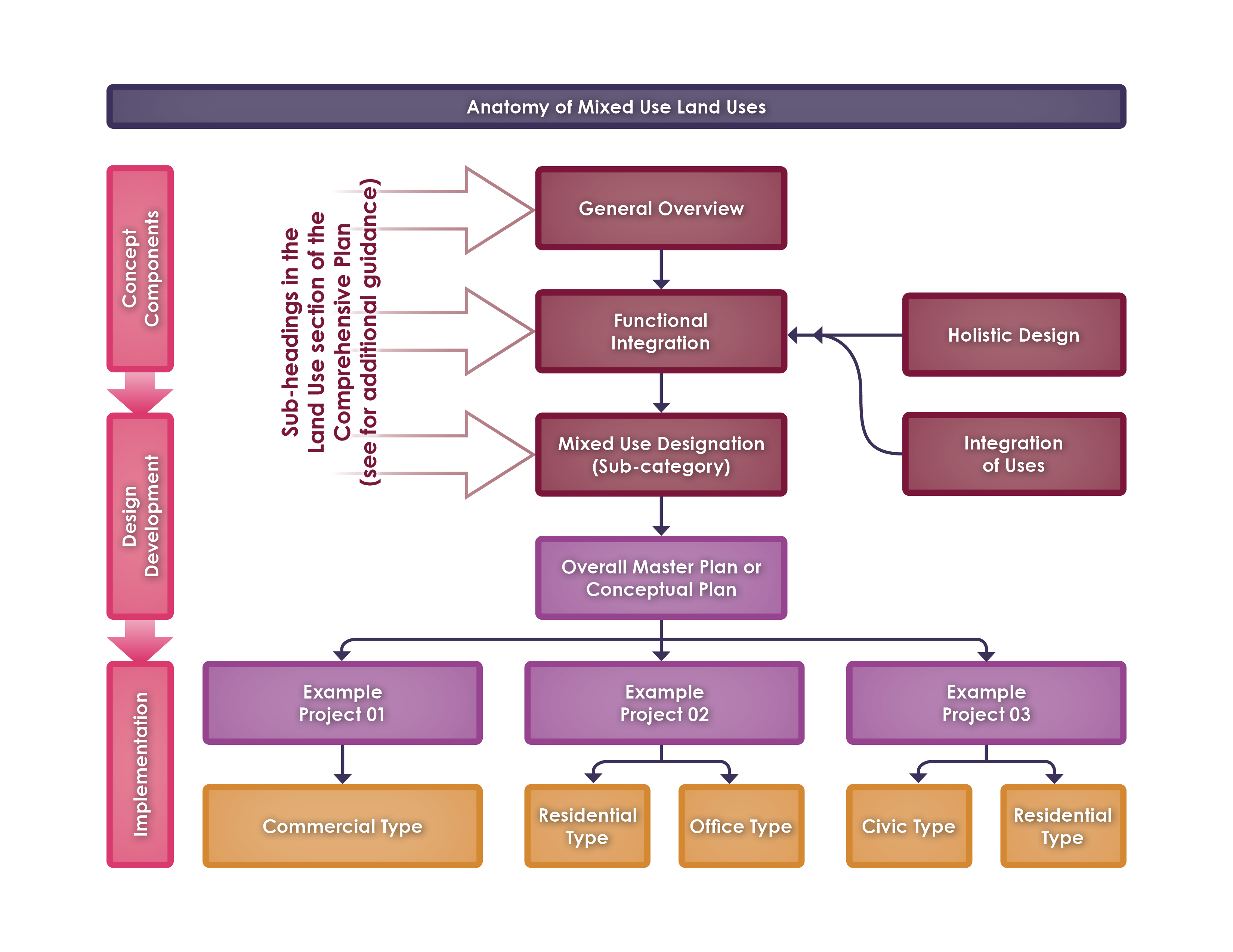
Holistic Design
The design of quality mixed use areas is not accomplished by merely including a variety of land use types, elements and features, but by the manner in which such elements and features are seamlessly integrated towards the purpose and vision of mixed use. The uses and site elements of a proposed mixed use project will be designed foremost around the idea of visible, attractive, and accessible destinations. The designer(s) must purposefully layout features to create focal elements that are visibly and physically linked within a development, to ensure that residents and employees have prioritized access to the places and services of most interest. The following design principles should be thoughtfully considered as part of a project within a mixed use area:
- Mixed use areas are to be centered around spaces that are well-designed public and quasi-public centers of activity. Spaces must be designed with community supportive purpose, incorporate permanent design elements with features to promote frequent use, and support amenities that foster a wide variety of interests ranging from relaxation to play. These areas must be strategically integrated into the overall development, interconnected with meaningful points of interest, prioritize pedestrian infrastructure, be highly visible and accessible, and designed to enhance both the adjacent uses and larger mixed use area. See also figures: FB5, FC6, FC7.
- In developments where multiple commercial and/or office buildings are proposed, the buildings should be arranged to create some form of common, usable area, such as a plaza or green space. See also figures: FC8, FC9, FD2.
- Open space should be purposeful in supporting a visible community and utilized to enhance synergies between residential and non-residential uses. See also figures: FC7, FC9, FD2.
- Open space should be prioritized along natural or naturalized amenities (i.e. creeks and canals), integrated with pathways and pedestrian corridors, and located away from site features that may obscure visibility and attract dangerous or illegal behavior. See also figures: FC1, FC2.
- Commercial drive aisles must contemplate a pedestrian friendly built environment with a minimal number of conflict points, and oriented so that aisle ingress and egress is generally parallel to multiuse pathways, sidewalks, and linear open space. Drive aisles supporting primary pedestrian connectivity for a site must feel safe, and should include planted and/or hardscaped parkway treatment, or other enhanced separation with both aesthetic and safety benefits. See also figures: FC1.
- All mixed use projects should be accessible to adjacent neighborhoods by both automotive and alternative-vehicular transportation opportunities. Pedestrian circulation must be convenient and interconnect different land use types. Vehicle connectivity must not rely on arterial streets for neighborhood access. See also figures: FA3, FA4, FB3, FB4.
- A mixed use project should be designed to support alternative transportation such as public transit stops, park-and-ride lots, other ride sharing services including auto, bike, or scooter, and/or other innovative or alternative modes of transportation. Alternative transportation improvements should be integrated as functional, convenient, and comfortable spaces. Electric charging stations for a variety of transportation modes is encouraged.
- Non-residential buildings should transition to and compliment adjacent residential buildings in mass and form, and include safe and meaningful mitigation for operational impacts such as loading docks, storage, and outdoor equipment. See also figures: FB2, FB4.
- New buildings on pad sites adjacent to existing single-family neighborhoods should be limited to no more than a 1-story disparity in building height (or floor height equivalent). Natural features, differences in grade, and other context sensitive neighborhood preservation design features should be considered with transitions.
- Transitions between different residential product types and dissimilar land uses should include the use of use alleys, roadways with landscaped parkways, or highly connected open space. The use of barriers such as closed vision fencing or walls that limit connectivity and reduce visibility are typically not appropriate as transitions. See also figures: FB1, FB2.
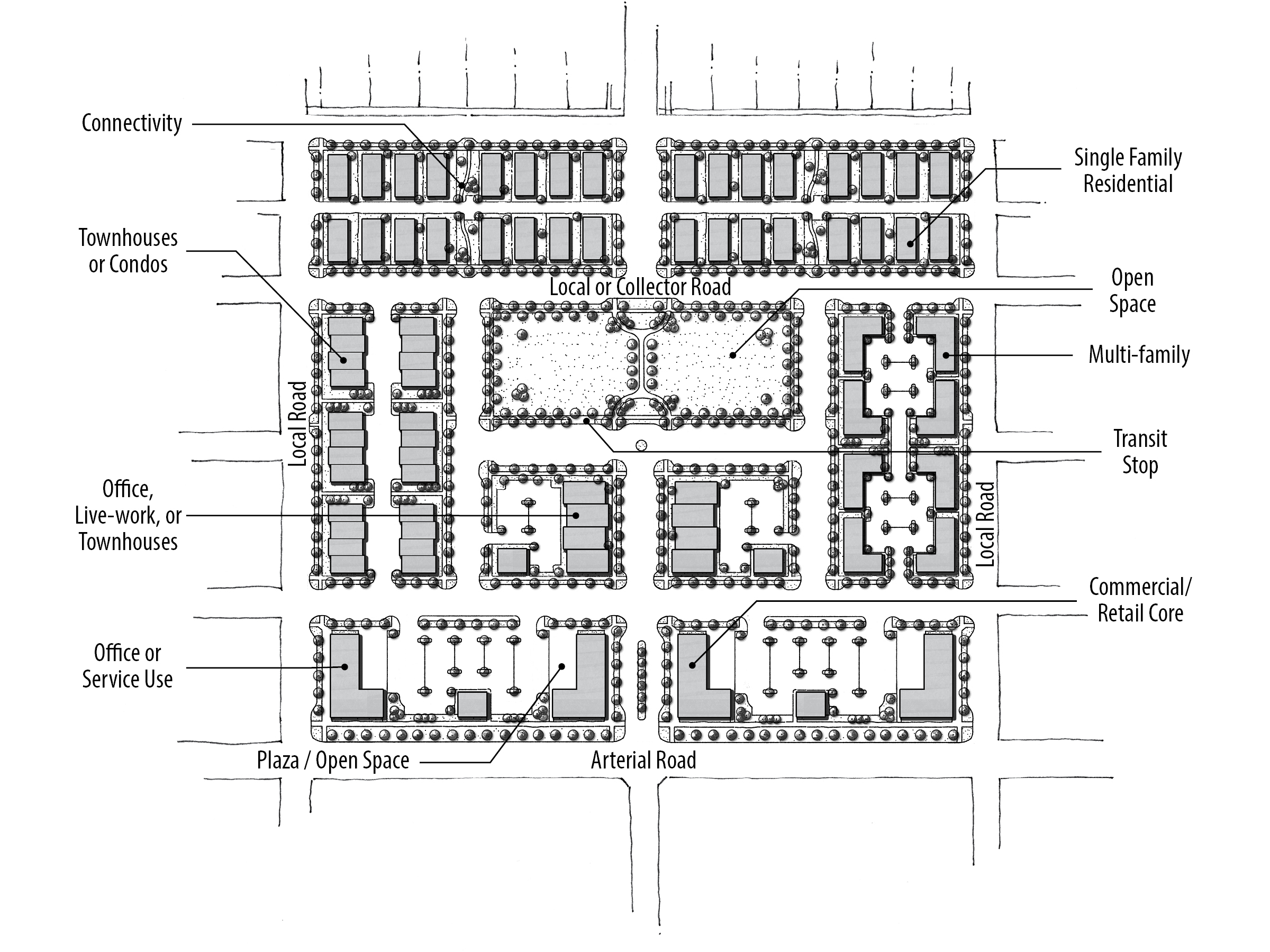
Figure 3C
Mixed Use Concept Diagram. See also Appendix, Figure FA1 for Color Diagram with markup.
Mixed Use Sub-Categories
There are five designations (sub-categories) of Mixed Use that are identified throughout the City of Meridian and the Meridian Area of City Impact: Neighborhood, Community, Regional, Interchange, and Non-Residential. This section further describes the purpose, intent, and development design principles for these designations. In addition, there are three sub-categories of the Mixed Use designation that are solely permitted in the Ten Mile Interchange Specific Area: Commercial, Residential, and Lifestyle Center. For more detailed descriptions of the land use designations in the Ten Mile area, see below, and also the Ten Mile Interchange Specific Area Plan.
Every mixed use designation includes a specific range of densities and coverage that generally allow for a mixed use area to realize a diversity of use types and to achieve its stated purpose. Recognizing the dynamic nature of mixed use areas, additional flexibility is afforded to these ranges through other referenced policies. Ultimately, any mixed use project must work towards the purpose and intent statements, including availability of goods and services to the community, and must offset impacts by providing quality of life opportunities not typically achievable through other single use areas of the City. The base land use coverage ranges are a starting point, with exceptions expected to include justification not on current market conditions, but the health and wellbeing of the community, and the market potential and buildout over time for the service area of each mixed use designation.
Conditions may exist within some mixed use areas that influence these metrics. For example, significant grade and access limitations may better support reduced intensities. Other land, with high visibility and access, may for example represent an opportunity to provide increased acreage for large employment, or reduced residential ratios when a service provider acquires significant prime acreage. However, examples like these will not be used to justify increased residential intensities outside of the specific allowances that are described within each mixed use designations.
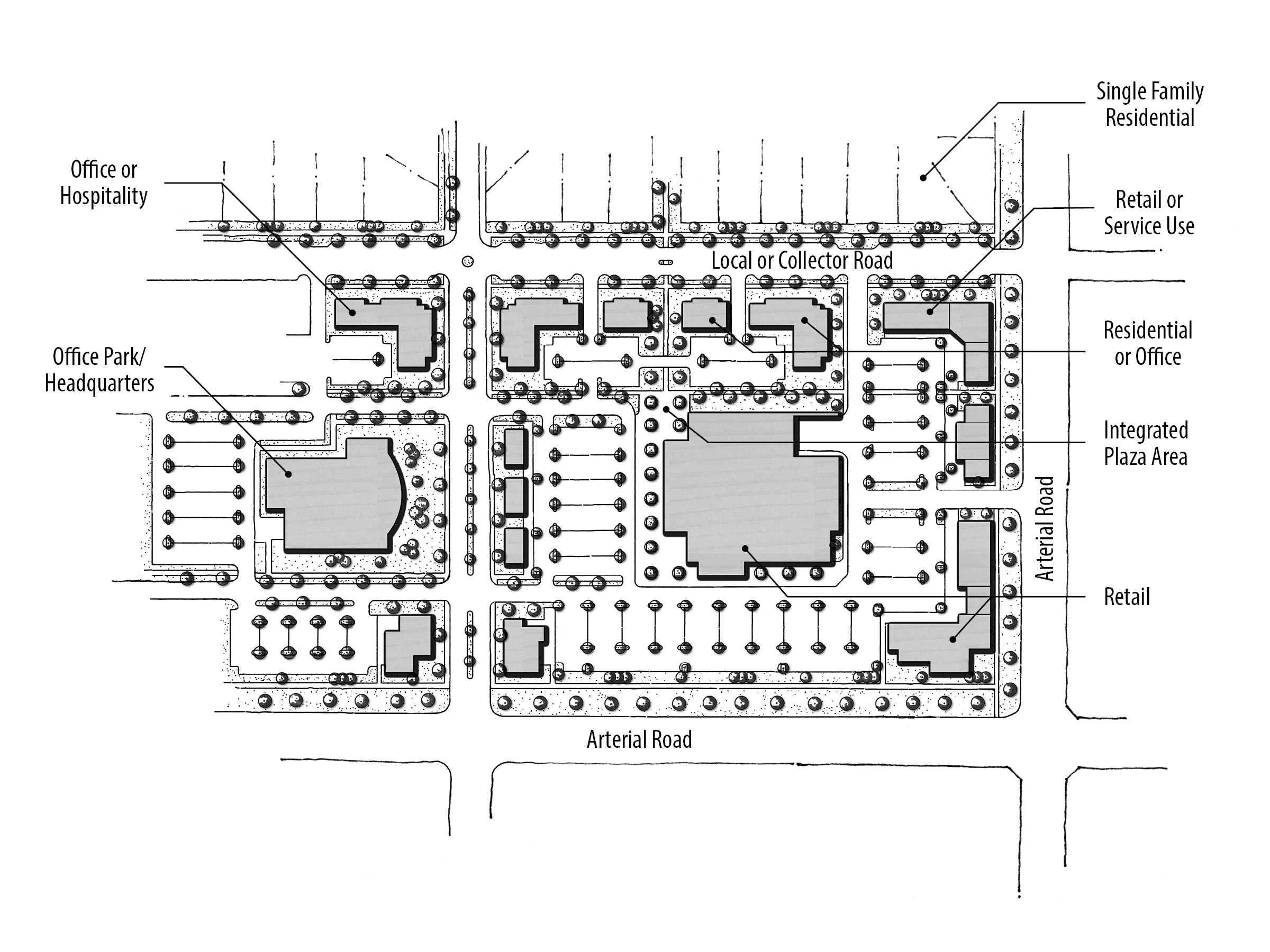
Mixed Use Neighborhood (MU-N)
The purpose of this designation is to allocate areas where neighborhood-serving uses and dwellings are seamlessly integrated into the urban fabric.
The intent is to avoid predominantly single-use developments by incorporating a variety of uses. Land uses in these areas should be primarily residential with supporting non-residential services.
Figure 3D
Mixed Use Neighborhood Concept Diagram. See also Appendix, Figure FA2 for Color Diagram with Markup.
Non-residential uses in these areas tend to be smaller scale and provide goods or services that people typically do not travel far for (approximately one mile) and need regularly. Employment opportunities for those living in the neighborhood are encouraged. Connectivity and access between the non-residential and residential land uses is particularly critical in MU-N areas. Tree-lined, narrow streets are encouraged. Developments are also encouraged to be designed according to the conceptual MU-N plan depicted in Figure 3D.
In reviewing development applications, the City will consider the following items in MU-N areas:
- Development must comply with the Functional Integration principles for development in all Mixed Use areas.
- Residential uses are expected to comprise between 30% and 60% of the development area, with gross densities ranging from 6 to 12 units/acre (of the residential area).
- Multiple residential product types are desired within a single mixed use area. See Sample uses appropriate in MU-N areas, below.
- A street pattern grid is encouraged for residential areas, and most blocks should be no more than 600’ long, similar to Old Town; larger blocks are allowed parallel to arterial streets and integration of natural features is encouraged.
- Supportive and proportional public and/or quasi-public spaces and places should comprise a minimum of 10% of the development area.
- Where the development site has transit available or stops are planned, an additional 10% of the site may be dedicated to residential uses. Alternatively, this bonus may be applied where the development site is within one-mile of planned transit stops or an identified employment area, and where last-mile transportation features are incorporated into the site including thoughtfully located and integrated ride share parking, commensurate with potential trip capture. Other innovations to reduce traffic and/or parking impacts and capture local trips may be considered.
- Sample uses appropriate in MU-N areas include: single-family homes, alley-loaded single-family homes, single-family homes with accessory dwelling units, townhouses, small-scale multi-family developments such as fourplexes, condominiums, neighborhood grocers, drug stores, coffee/sandwich/ice-cream shops, vertically integrated buildings, live-work spaces, dry cleaner/laundromat, salons/spas, daycares, neighborhood-scale professional offices, gift shops, schools, parks, churches, clubhouses, public uses, and other appropriate neighborhood-scale uses. Sample zoning includes: R-8, R-15, TN-R, TN-C, L-O, and C-N.
Mixed Use Community (MU-C)
The purpose of this designation is to allocate areas where community-serving uses and dwellings are seamlessly integrated into the urban fabric.
The intent is to integrate a variety of uses, including residential, and to avoid mainly single-use and strip commercial type buildings.
Figure 3E
Mixed Use Community Concept Diagram. See also
Appendix, Figure FA3 for Color Diagram with markup.
In reviewing development applications, the City will consider the following items in MU-C areas:
- Development must comply with the Functional Integration principles for development in all Mixed Use areas.
- Residential uses are expected to comprise between 20% and 50% of the development area, with gross densities ranging from 6 to 15 units/acre (of the residential area).
- Supportive and proportional public and/or quasi-public spaces and places should comprise a minimum of 5% of the development area are required.
- Where the development site has transit available or stops are planned, an additional 15% of the site may be dedicated to residential uses. Alternatively, this bonus may be applied where the development site is within one-mile of planned transit stops or an identified employment area, and where last-mile transportation features are incorporated into the site including thoughtfully located and integrated ride share parking, commensurate with potential trip capture. Other innovations to reduce traffic and/or parking impacts and capture local trips may be considered.
- Sample uses appropriate in MU-C areas include: All MU-N categories, community scale grocers, clothing stores, garden centers, hardware stores, restaurants, banks, drive-thru facilities, auto service station, retail shops, and other appropriate community-serving uses. Sample zoning includes: R-15, R-40, TN-R, TN-C, C-C, and L-O.
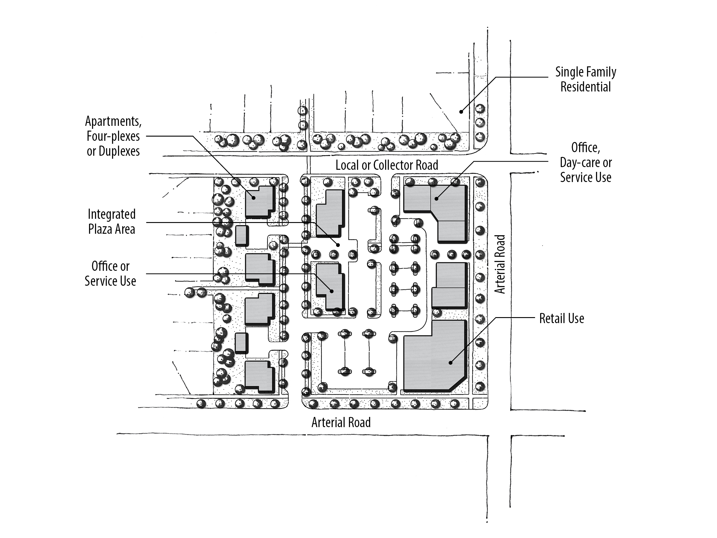
Mixed Use Regional (MU-R)
The purpose of this designation is to provide a mix of employment, retail, residential dwellings, and public uses near major arterial intersections.
The intent is to integrate a variety of uses together, including residential, and to avoid predominantly single use developments such as a regional retail center with only restaurants and other commercial uses.
Figure 3F
Mixed Use Regional Concept Diagram. See also Appendix, Figure FA4 for Color Diagram with Markup
In reviewing development applications, the City will consider the following items in MU-R areas:
- Development must comply with the Functional Integration principles for development in all Mixed Use areas.
- Residential uses are expected to comprise between 10% and 30% of the development area, with gross densities ranging from 6 to 40 units/acre (of the residential area).
- The minimum for non-retail commercial uses such as light-office, office, clean industry, or entertainment uses, is 20% of the mixed use area.
- Retail commercial uses should comprise a maximum of 50% of the development area.
- Where the development proposes public and quasi-public uses to support the development, the developer may be eligible for the following additional coverage area bonuses for retail or residential development (beyond the base allowance):
- For land that is designated for a public use, such as a library or school, the developer is eligible for a 2:1 bonus (e.g. - if there is a one-acre library site planned and dedicated, the project would be eligible for two additional acres of retail development).
- For active and shared open space or passive recreation areas, such as a park, tot-lot, or playfield, the developer is eligible for a 2:1 bonus (e.g. - if a park is 10 acres in area, the site would be eligible for 20 additional acres of retail development).
- For plazas that are integrated into a retail project, the developer would be eligible for a 6:1 bonus. Such plazas should provide a focal point (such as a fountain, statue, and water feature), seating areas, and some weather protection. That would mean that by providing a half-acre plaza, the developer would be eligible for three additional acres of retail development.
- Where the development site has transit available or stops are planned, an additional 20% of the site may be dedicated to residential uses. Alternatively, this bonus may be applied where the development site is within one-mile of planned transit stops or an identified employment area, and where last-mile transportation features are incorporated into the site including thoughtfully located and integrated ride share parking, commensurate with potential trip capture. Other innovations to reduce traffic and/or parking impacts and capture local trips may be considered.
- Sample uses, appropriate in MU-R areas would include: All MU-N and MU-C categories, entertainment uses, major employment centers, clean industry, and other appropriate regional-serving uses. Sample zoning includes: R-15, R-40, TN-C, C-G, and M-E.
Mixed Use Non-Residential (MU-NR)
The purpose of this designation is to designate areas where new residential dwellings will not be permitted, as residential uses are not compatible with planned and/or existing uses in these areas.
Figure 3G
Mixed Use Non-Residential Concept Diagram.
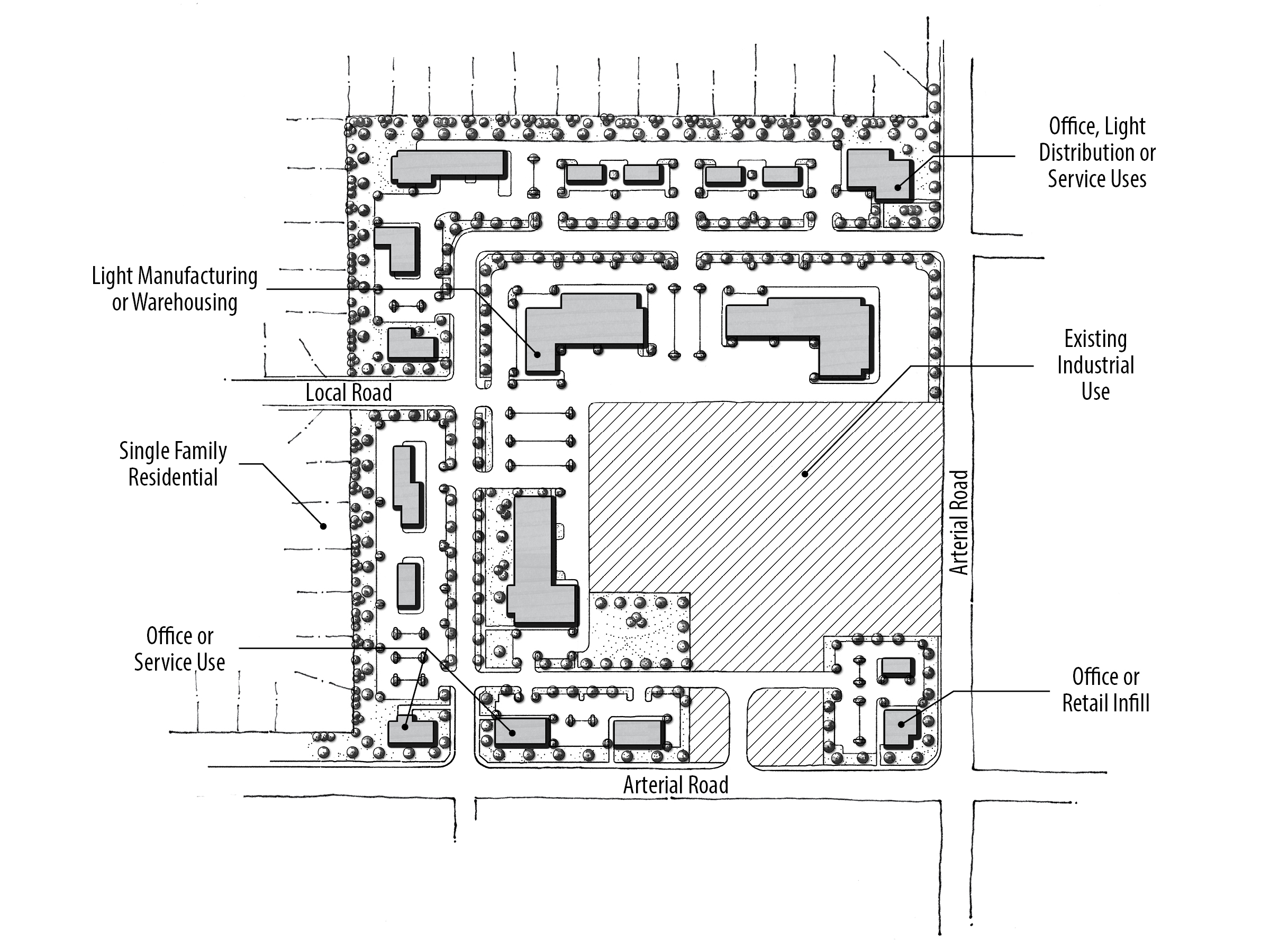
For example, MU-NR areas are used near the City’s Wastewater Resource Recovery Facility and where there are heavy industrial or other hazardous operations that need to be buffered from residential. Developments are encouraged to be designed similar to the conceptual MU-NR plan depicted in Figure 3G.
In reviewing development applications, the City will consider the following items in MU-NR areas:
- No new residential uses will be permitted (existing residential may remain).
- Development is not required to comply with the minimum number of use types in the Functional Integration principles; only two use types are required.
- There is neither a minimum nor maximum imposed on non-retail commercial uses such as office, industry, or warehouse uses. Food service and restaurants are encouraged in support of other adjacent employment oriented uses.
- A transitional use such as professional office or public/quasi-public plaza is encouraged on the perimeter of the MU-NR areas between any existing or planned residential development.
- Sample uses, appropriate in MU-NR areas would include: employment centers, professional offices, flex buildings, warehousing, industry, storage facilities and. Sample zoning includes: C-C, C-G, L-O, M-E, H-E, I-L, and I-H.
Mixed Use Interchange (MU-I)
The purpose of this designation is to call out areas around SH-16 interchanges, and to acknowledge that this land is very visible. These areas will be served by interchange ramps and restricted local access. There are two SH-16 interchange areas, one located at US 20-26 and one at Ustick Road, that differ from the other Mixed Use categories in that a much stronger emphasis will be placed upon gateway elements and traffic flow/trip generation factors when reviewing new land use applications. Uses in these areas will need to be compatible with the impacts of a freeway interchange. These areas are not intended for high volume trips, either aggregated over the larger planned MU-I area, or as individual use types. The intention is to protect the immediate vicinity of the interchange from traffic conflicts and shift the high traffic-generating uses away from the immediate vicinity of the interchange to other, nearby areas.
In reviewing development applications, the City will consider the following items in MU-I areas:
- Development must comply with the Functional Integration principles for development in all Mixed Use areas.
- Areas in close proximity to interchanges and interchange ramps (and which are further from public access to major roadways) are not appropriate for residential uses intended for senior care, low-income, or other residents and families that may be more sensitive to noise, emissions, or adversely impacted by increased travel times to essential services.
- Land uses within the MU-I areas and adjacent to the SH-16 corridor will be carefully examined for their potential impacts on nearby existing and planned retail and restaurant uses in Commercial and Mixed future land use areas.
- A traffic impact study or other traffic analysis may be required for developments in these areas.
- Vehicular access points must be located as far as practical from interchange ramps. Future uses should be planned to integrate with a frontage/backage road type circulation system, ensuring high visibility property is able to develop with desired uses such as office or technology/research parks to support the economy, job-base, and reduce local trips on the regional network.
- Regional ridesharing, park-and-ride and transit transfer facilities are strongly encouraged.
- The SH-16/US 20-26 interchange will be one of only two regional gateways to the City of Meridian for travelers coming from north of the Boise River (the other being Linder Road). As such, buildings, landscaping, and other design features at this interchange should reflect Meridian’s heritage, quality, and character.
- Examples of uses include schools, post office or library branches, office uses, light residential (low density with minimal trip generation) developments, athletic clubs, and technology/research parks.
Ten Mile Interchange Specific Area Plan
The City developed a specific plan for approximately 2,800 acres bordered (roughly) by Linder Road to the east; McDermott Road to the west; the Union Pacific Railroad line to the north; and ½ mile south of Overland Road on the south. The specific area plan is an addendum to this Comprehensive Plan and places an emphasis on a mix of uses, both residential and commercial; new employment areas; higher density residential; a planned collector road network; and design guidelines.
It is important to note that the Ten Mile Interchange Specific Area Plan (TMISAP) uses different land use designations than the rest of the FLUM. While there are some similarities (for example Low Density Residential), there are also new designations which do not exist outside of this Ten Mile area. It is expected that development within Ten Mile area Mixed Use designations be designed consistent with the Functional Integration principles herein. The TMISAP was adopted as an addendum to the City of Meridian Comprehensive Plan on June 19, 2007, by Resolutions Numbers 07-563 (Map) and 07-564 (Text). Development in the Ten Mile Interchange area will also be reviewed using the TMISAP. See the Ten Mile Interchange Specific Area Plan for more details of this area.
Civic Land Uses
The purpose of this designation is to preserve and protect existing and planned municipal, state, and federal lands for area residents and visitors. This category includes public lands, law enforcement facilities, post offices, fire stations, cemeteries, public utility sites, public parks, public schools, and other government owned sites within the Area of City Impact.
Park Land Uses (Symbol)
The purpose of this designation is to preserve and protect existing and future public neighborhood, community, regional, and urban parks. The park locations designated on the Future Land Use Map are the most current and should be used for planning purposes. Constructed parks are further described in the Existing Conditions Report Addendum.
School Land Use (Symbol)
The purpose of this designation is to provide areas throughout the Area of City Impact which provide educational opportunities, community gathering places, and green space.
Fire and Police Stations (Symbol)
The purpose of this designation is to preserve and protect existing and planned fire and police station locations throughout the Area of City Impact which provide efficient emergency response.
Entryway Corridors
The City feels it is important to identify roadways that introduce and welcome both visitors and residents to the City of Meridian. These roadways are noted as entryway corridors on the FLUM and are subject to additional standards within the Unified Development Code.
Transit Stations and Transit Oriented Development (Symbol)
The Transit Station designation is used for areas where transit supported uses are envisioned along the railroad and other predefined corridors Within areas around these symbols, the City seeks projects that incorporate features which enhance alternative transportation and are transit friendly. Said developments are envisioned within commercial activity centers and should incorporate the following development and design principles:
- A mix of land uses
- Building orientation that provides the maximum level of services to pedestrians, bicyclists and transit users
- Alternative transit features such as a bus shelter (where approved by VRT), bicycle lockers or similar facilities
- Residential densities that are at least 8 dwelling units per acre and designed to comply with the Traditional Neighborhood design standards in the Unified Development Code
- Park and ride lots and other transit-supportive facilities are encouraged at interchanges throughout the City. VRT and ACHD Commuteride should be partners in determining appropriate facilities at each interchange.
- New types of street cross sections, including multi-purpose pathways, buffered bike lanes and managed lands that can accommodate new forms of vehicles from electric bicycles, scooters, autonomous vehicles and future dedicated transit.


Utilities and Infrastructure
Introduction
Utilities are the foundation to quality of life within cities. Clean drinking water, electricity, stormwater management, natural gas, telecommunications, and wastewater make city-living possible. Adequate, efficient, accessible, and affordable utilities contribute to attracting business, reducing the environmental footprint of urban development, and playing a vital role in social development. Public facilities discussed in this section include domestic water service, sewer collection, sewage treatment, and other independently operated utilities (such as power, natural gas, and communications). The Utilities Element works in concert with the Growth and Land Use Elements to ensure adequate infrastructure is in place to accommodate existing and future needs.
Background
The City owns and operates its own domestic water and sewer services; however it relies on other entities for some of the other essential services. Therefore, coordination between the City and each service provider is vital in planning and prioritizing of expansion areas, and continued service to existing locations.
With the exception of a portion of north Meridian where SUEZ Water provides service, the City’s Public Works Department provides water to Meridian residents. In order to keep up with water demand, new wells and water line extensions are constructed and generally funded by new development.
With a vision for sustainability, Meridian works to conserve ground water and reduce discharge flows into the Boise River. As Meridian is located in an arid climate, using recycled water is a “drought-proof” water supply that reduces demand on municipal supply, frees up agricultural water for agricultural uses, and lowers effluent flow to the Boise River.
Water Service
The City’s domestic water system is currently supported by a series of deep wells, booster pump stations, multiple reservoirs, and pipeline. In order to keep up with water demand, the City has constructed, on average, one new well per year, each funded by connection fees and charged to new development. Water line extensions to new developments are generally paid for and constructed by developers. Although the City plans new wells and reservoirs, the specific locations to those facilities are largely dictated by growth patterns, and will continue to be funded by new development. In a few small areas of the City, SUEZ provides water service to residents and businesses, and new development must coordinate this service with both the City of Meridian and with SUEZ.
Sewer Collection & Treatment
The sewer (also known as wastewater) collection system in the City consists of pipe and lift (pump) stations. Sewage generally flows by gravity to the Wastewater Resource Recovery Facility located northwest of the Ten Mile/Ustick intersection. The Sewer Master Plan includes development of a computer model which helps Public Works staff identify priority areas for development in the City as well as segments of the existing sewage collection system that are approaching capacity. Future capital improvements are prioritized to upgrade the lines that are approaching capacity. The City will evaluate the need for additional expansion projects based on the Sewer Master Plan and model.
The Wastewater Resource Recovery Facility (WRRF) consists of primary, secondary, and tertiary treatment followed by disinfection. Treated effluent is discharged to Five Mile Creek. The City continues to upgrade the facility following its current Facility and 5 year Capital Improvement Plans. This facility is regulated by a National Pollutant Discharge Elimination System (NPDES) Wastewater discharge permit from the Environmental Protection Agency (EPA).
With a vision for sustainability, Meridian holds a Citywide Class A Recycled Water Permit. Recycled water is a highly treated water resource generated at the WRRF that meets standards for reuse, as established by the Idaho Department of Environmental Quality. The WRRF makes this recycled water available free of charge in supported areas.
Garbage and Recycling
Republic Services (Republic) is the solid waste and recycling collection contractor for the City of Meridian. Republic is dedicated to providing reliable and innovative recycling and waste reduction programs to the City. The City has established a Solid Waste Advisory Committee (SWAC) to help set steer a curbside recycling program and to advise the City Council on other solid waste issues. The SWAC works in conjunction with Republic staff. The SWAC focuses its attention on growing the solid waste and recycling programs and making them as user friendly as possible.
Irrigation
Meridian irrigation water is largely supplied by a series of canals and laterals diverted from the Boise River. There are many irrigation districts with operations in Meridian’s Area of City Impact, but the two largest affecting most of Meridian are the Settler’s Irrigation District and Nampa and Meridian Irrigation District (NMID).
Power
Idaho Power Company provides electrical services throughout the City of Meridian and its Area of City Impact. Idaho Power is a public service company regulated by the Idaho Public Utility Commission (IPUC), the Federal Energy Regulatory Commission (FERC), and the state regulatory commissions of Idaho and Oregon. Idaho Power’s long-range electrical plan for Meridian and the larger area is called the Eastern Treasure Valley Electrical Plan, which is listed in the adopted by reference section of this Plan.
Natural Gas
Intermountain Gas Company is the sole provider of natural gas in southern Idaho, including Meridian. Meridian is serviced by dual, high pressure natural gas pipelines that bisect the southwest part of the Area of City Impact. These lines are an important consideration for any development adjacent to them.
Communications
Sparklight and CenturyLink provide landline phone and cable television agreements in the area. Sparklight (formerly CableOne) has a franchise agreement with the City for traditional cable T.V. services. There are also a number of other fiber and wireless providers which also offer telecommunication services.

